How UltraSystems Uses the Leading GIS Mapping Software Application from ESRI to Analyze Projects.
UltraSystems has a multi-disciplinary team of talented and highly experienced environmental planners, scientists, archaeologists, biologists, engineers, Geographic Information Systems (GIS) specialists and support staff to conduct the work necessary to produce documents for the California Environmental Quality Act and National Environmental Policy Act (CEQA/NEPA) process.
Featured Photo (above): Environmental analysis of the plant species and habitats for the Palm Crest Elementary School Modernization Project, La Cañada School District, City of Flintridge, California.
UltraSystems’ lead GIS Analyst, Stephen Chesterman, B.Eng. says that “GIS is a powerful tool that allows us to display complex and disparate information on a figure with corresponding quantified information in a tabular format, such as vegetation cover acreages, number of trees, and number of archaeological findings, in a simple and easy to understand way. For example, we can demonstrate that a development avoids or reduces any lasting impact to those issues of most concern, whether it be associated with planning areas, biological resources, or archeological resources.”
Chesterman adds that, “the top 3 GIS uses in our environmental work include:
- Data Storage – Compiling a geospatially aware database of all project features including GPS surveys.
- Geospatial Analysis – Analyzing project survey data (points, lines, polygons) in a 2D context displayed on an aerial overlay, such as wildfire boundaries, vegetation communities, species locations, topographical and geomorphological features, delineation of the lateral extents of wetlands and waters, and other such field observations.
- Presentation – Creating maps showing a project’s relationship to its surroundings such as its proximity to areas most at threat of wildfire and presenting analysis results.”
GIS – It’s Not Just Mapping
The ArcInfo suite of applications from Environmental Systems Research Institute (Esri) includes powerful software programs that take geospatial data along with a corresponding database to show relational aspects of an area through mapping layers. The powerful database behind the displayed map is what allows our Environmental Planners to hone in on specific information that may be needed to mitigate an environmental impact in a project. By turning layers on and off in the map view, project details are sorted, catalogued and retained in a visually remarkable way to allow complex analysis by the team for our clients.
Remote Sensing
ArcGIS includes a geospatial system for imagery-driven insights to give our clients a deeper understanding of their project site before taking decisive actions on location. With imagery and GIS combined in a geospatial technology system, static images are transformed into digital representations, creating richer information maps that can drive smarter decisions. For example, a drone flight captures real time pictures of a project site from overhead. Then, back at the office, the software tools generate and display an accurate three-dimensional, feature-rich map transforming the images into a desktop reality. Next, our clients can view large volumes of imagery and perform a powerful analyses of the project site extracting insights at scale, including change detection.
Location Intelligence
On a recent project, UltraSystems surveyed approximately 100 trees on the property of the Paradise Canyon Elementary School, part of the La Cañada School District, in the City of Flintridge, California. The data was gathered by our Certified Arborist and Habitat Restoration Specialist, Matthew Sutton, ISA, who performed an in-person inspection and tally of the trees on campus for an Arborist Survey The survey identified tree species within the campus boundary, shown in the figure below, by using a GPS unit with sub-meter accuracy to record all trees greater than two inches in diameter. Using ArcGIS mapping software, our GIS Analysts compiled the data and completed the tree compendium to convert exact measurements into an intelligent locational map for the school district to use to evaluate the possible environmental impacts of planned campus construction projects.
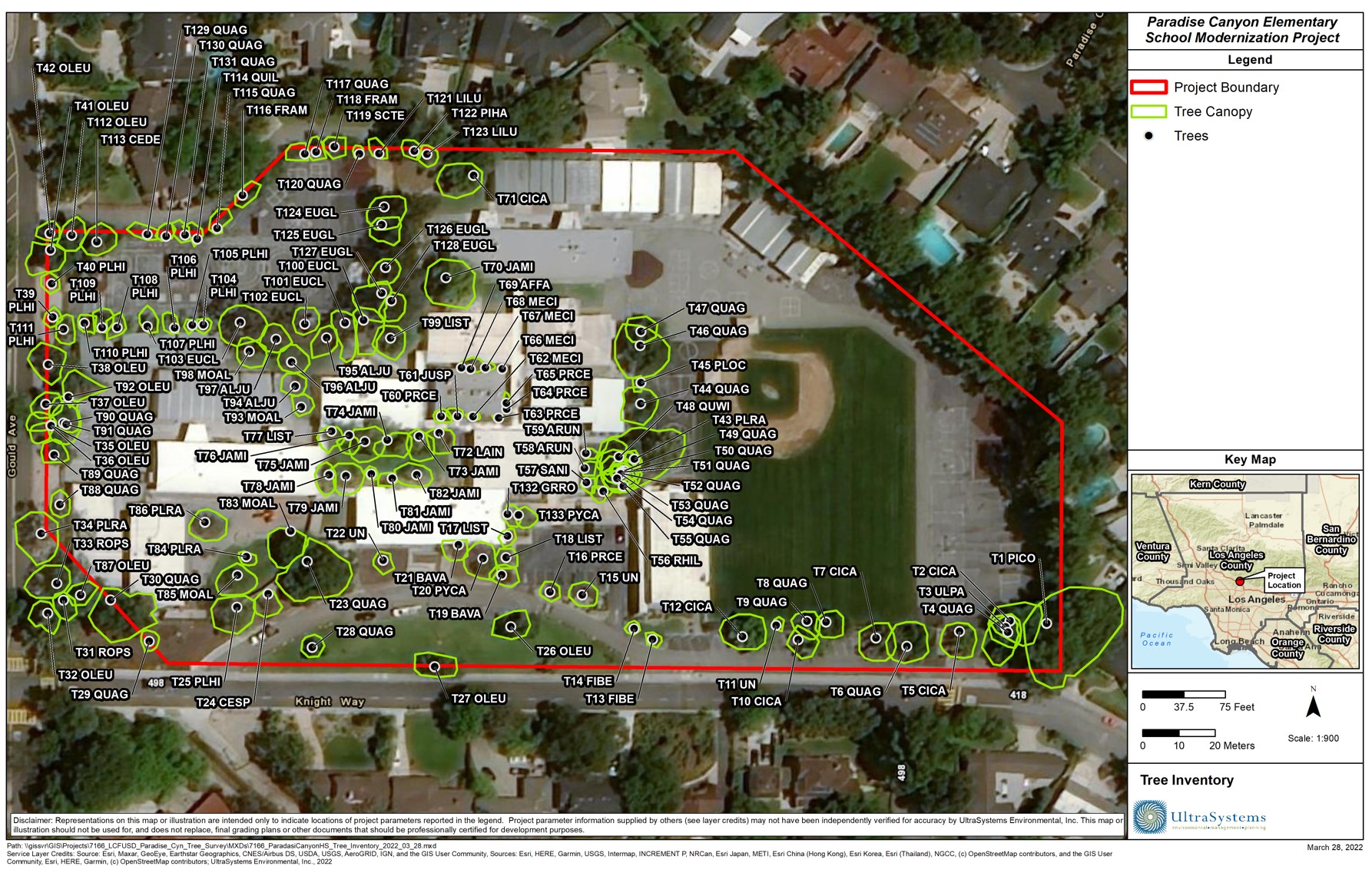
Photo: Arborist/Tree Survey for Paradise Canyon Elementary School, La Cañada School District, City of Flintridge, California.
With CEQA/NEPA goals in mind, the task becomes clear on how to effectively use GIS in the environmental evaluation process. Our GIS team regularly works with our in-house experts to gather data at the project site and turn raw information into insightful research. Biological and Cultural Resources depend on mapping preciseness to guide clients through mitigation and monitoring updates of their new development sites, in accurate, real time, every day. Our clients are better served through this powerful technology and the expertise of the UltraSystems’ team.
![]() About ESRI
About ESRI
Esri is an international supplier of geographic information system software, web GIS and geodatabase management applications. The company is headquartered in Redlands, California. The company was founded as the Environmental Systems Research Institute in 1969 as a land-use consulting firm.
![]() About UltraSystems
About UltraSystems
UltraSystems, founded in 1994, is a multi-disciplinary, full service environmental consulting and planning firm serving both the public and private sectors. The 28-year-old firm provides expertise in development planning; site selection and analysis; CEQA and NEPA compliance; technical studies, and environmental compliance during construction. UltraSystems Environmental is certified as a WBE, SBE, DBE and WOSB company and is headquartered in Irvine, California.
